| Collector | Balslev, H. |
| Number | 7692 |
| Collected with | C. Grandez, G. Criollo, D. Pedersen, L. Stewart, I. Nicolajsen, W. Eiserhardt, D. Lindvig |
| Country | Peru |
| Subpart | Junín |
| County | |
| Locality | Just N of the road along Río Tambo 5km S of Atalaya (UTM 8809820 S; 634552 W). Tall rainforest on long, not steep slope. |
| Coordinates | 10° 45' 51.2'' S 73° 46' 9.8'' W |
| Minimum elevation (m) | 371 |
| Maximum elevation (m) | 0 |
| Start date | 2008/10/11 |
| End date | 0/00/00 |
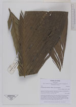
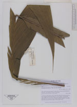
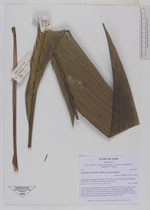
| Family | Arecaceae |
| Identification | Geonoma macrostachys var. macrostachys Mart. |
| Determined by | H. Balslev |
| Identification qualifier | |
| Field notes | Acaulescent, solitary palm. Leaves 10 per stem; sheath 32cm long, open; petiole 34cm, margined; rachis 95cm; lamina 120 x 50cm; pinnae 3 per side, basal 33cm, middle 34cm, apical 34cm. Inflorescence interfoliar; prophyll 6cm long; peduncular bract 31cm long, brown, inserted at the base; peduncle 115cm long, 0.4cm thick, smooth; Flowers sunken. Transect HB341-SU05. |
_HB7692_Geonoma_macrostachys_macrostachys.jpg)
_HB7692_Geonoma_macrostachys_macrostachys.jpg)
_HB7692_Geonoma_macrostachys_macrostachys.jpg)
|