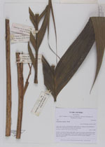
| Collector | Balslev, H. |
| Number | 7690 |
| Collected with | C. Grandez, G. Criollo, D. Pedersen, L. Stewart, I. Nicolajsen, W. Eiserhardt, D. Lindvig |
| Country | Peru |
| Subpart | Junín |
| County | |
| Locality | Just N of the road along Río Tambo 5km S of Atalaya (UTM 8809849 S; 634567 W). Tall rainforest on long, not steep slope. |
| Coordinates | 10° 45' 50.3'' S 73° 46' 9.3'' W |
| Minimum elevation (m) | 381 |
| Maximum elevation (m) | 0 |
| Start date | 2008/10/11 |
| End date | 0/00/00 |
| Family | Arecaceae |
| Identification | Geonoma camana Trail |
| Determined by | H. Balslev |
| Identification qualifier | |
| Field notes | Solitary, acaulescent, large rosette palm. Leaves 12 per stem; sheath 60cm, open; petiole 35cm, margined, green; rachis 152cm; lamina 198 x 50cm; pinnae 17 per side, basal 33cm, middle 40cm, apical 60cm. Sterile voucher. Transect HB341-outside SU01. |
_HB7690_Geonoma_camana.jpg)
|