AAU Herbarium Database |
| New Search Modify Search |
| Collector | Balslev, H. |
| Number | 7687 |
| Collected with | C. Grandez, G. Criollo, D. Pedersen, L. Stewart, I. Nicolajsen, W. Eiserhardt, D. Lindvig |
| Country | Peru |
| Subpart | Junín |
| County | |
| Locality | Just NW of the road along Río Tambo 6km S of Atalaya (UTM 8807242 S; 634365 W). Tall rainforest on steep hills with many smaller gorges. |
| Coordinates | 10° 47' 15.2'' S 73° 46' 15.6'' W |
| Minimum elevation (m) | 330 |
| Maximum elevation (m) | 0 |
| Start date | 2008/10/10 |
| End date | 0/00/00 |
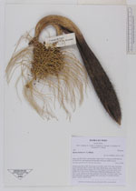
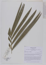
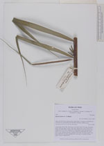
| Family | Arecaceae |
| Identification | Bactris halmoorei A.J.Hend. |
| Determined by | H. Balslev |
| Identification qualifier | |
| Field notes | Solitary palm. Roots 200, 20cm long, 0.2cm thick. Stem 3.5m long, 5cm thick; spines 3cm long, black. Leaves 12 per stem; sheath 20cm, open; petiole 75cm, round, red; rachis 209cm; lamina 229 x 95cm; pinnae 46 per side, basal 21cm, middle 53cm, apical 20cm. Inflorescence infrafoliar; peduncular bract 39cm long, woody, inserted at the base; peduncle 20cm long, 2cm thick; rachis 11cm long, branched to 1st order; rachillae 200, 14cm long, 0.1cm thick; flowers sessile. Transect HB340-SU82. |
_HB7687_Bactris_halmoorei.jpg)
_HB7687_Bactris_halmoorei.jpg)
_HB7687_Bactris_halmoorei.jpg)
_HB7687_Bactris_halmoorei.jpg)
_HB7687_Bactris_halmoorei.jpg)
_HB7687_Bactris_halmoorei.jpg)
_HB7687_Bactris_halmoorei.jpg)
| |
 Other records of Bactris halmoorei Other records of Bactris halmooreiThe map displays only records from the Aarhus Herbarium Database. The records may not represent the full distribution of Bactris halmoorei |
| New Search Modify Search |