| Collector | Balslev, H. |
| Number | 7686 |
| Collected with | C. Grandez, G. Criollo, D. Pedersen, L. Stewart, I. Nicolajsen, W. Eiserhardt, D. Lindvig |
| Country | Peru |
| Subpart | Junín |
| County | |
| Locality | Just NW of the road along Río Tambo 6km S of Atalaya (UTM 8807252 S; 634401 W). Tall rainforest on steep hills with many smaller gorges. |
| Coordinates | 10° 47' 14.8'' S 73° 46' 14.4'' W |
| Minimum elevation (m) | 359 |
| Maximum elevation (m) | 0 |
| Start date | 2008/10/10 |
| End date | 0/00/00 |
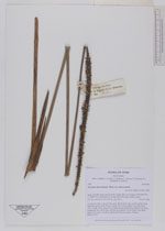
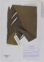
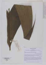
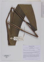
| Family | Arecaceae |
| Identification | Geonoma macrostachys var. macrostachys Mart. |
| Determined by | H. Balslev |
| Identification qualifier | |
| Field notes | Acaulescent palm. Leaves 10 per stem; sheath 19cm long, closed; petiole 60cm, margined, green; rachis 105cm; lamina 149 x 46cm; pinnae 3 per side, basal 50cm, middle 45cm, apical 47cm. Inflorescence interfoliar; prophyll 15cm long; peduncular bract 40cm long, soft, brown; peduncle 100cm long, 0.5cm thick; rachis 27cm long, 1cm thick, unbranched; flowers sunken. Transect HB340-SU76. |
_HB7686_Geonoma_macrostachys_macrostachys.jpg)
_HB7686_Geonoma_macrostachys_macrostachys.jpg)
|