| Collector | Balslev, H. |
| Number | 7684 |
| Collected with | C. Grandez, G. Criollo, D. Pedersen, L. Stewart, I. Nicolajsen, W. Eiserhardt, D. Lindvig |
| Country | Peru |
| Subpart | Junín |
| County | |
| Locality | Just NW of the road along Río Tambo 6km S of Atalaya (UTM 8807297 S; 634472 W). Tall rainforest on steep hills with many smaller gorges. |
| Coordinates | 10° 47' 13.4'' S 73° 46' 12.1'' W |
| Minimum elevation (m) | 369 |
| Maximum elevation (m) | 0 |
| Start date | 2008/10/10 |
| End date | 0/00/00 |
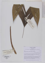
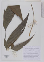
| Family | Arecaceae |
| Identification | Geonoma stricta var. trailii (Burret)A.J.Hend. |
| Determined by | H. Balslev |
| Identification qualifier | |
| Field notes | Cespitose, erect, understory palm. Stem 2m long, 0.6cm thick. Leaves 6 per stem; sheath 12cm, closed; petiole 16cm, green; rachis 35cm; lamina 53 x 22cm; pinnae 3 per side, basal 26cm, middle 30cm, apical 26cm. Inflorescence infrafoliar; peduncle 6cm long, 0.3cm thick; rachis 14cm long, 0.5cm thick, unbranched; flowers sunken. Transect HB340-SU64. |
_HB7684_Geonoma_stricta_trailii.jpg)
_HB7684_Geonoma_stricta_trailii.jpg)
|