AAU Herbarium Database |
| New Search Modify Search |
| Collector | Balslev, H. |
| Number | 7664 |
| Collected with | C. Grandez, G. Criollo, D. Pedersen, L. Stewart, I. Nicolajsen, W. Eiserhardt, D. Lindvig |
| Country | Peru |
| Subpart | Junin |
| County | |
| Locality | Just N of the road along Río Tambo 10km S of Atalaya (UTM 8804026 S; 634904 W). Tall rainforest on steep hills with some very deep gorges. |
| Coordinates | 10° 48' 59.8'' S 73° 45' 57.4'' W |
| Minimum elevation (m) | 296 |
| Maximum elevation (m) | 0 |
| Start date | 2008/10/09 |
| End date | 0/00/00 |
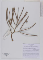
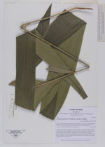
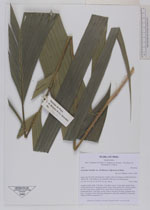
| Family | Arecaceae |
| Identification | Geonoma maxima var. chelidonura (Spruce)A.J.Hend. |
| Determined by | H. Balslev |
| Identification qualifier | |
| Field notes | Cespitose palm. Stem 2.5m long, 2cm diam. Leaves 11 per stem; sheath 20cm, closed; petiole 30cm, margined, green; rachis 38cm; lamina 80 x 80cm; pinnae 3 per side, basal 58cm, middel 63cm, apical 56cm. Inflorescence interfoliar; peduncular bract 12cm long, woody, brown, inserted at the base; peduncle 9cm long, 1cm thick; rachis 5cm long, branched to 2nd order; rachillae 9, 9cm long. Transect HB339-outside SU35. |
_HB7664_Geonoma_maxima_chelidonura.jpg)
_HB7664_Geonoma_maxima_chelidonura.jpg)
_HB7664_Geonoma_maxima_chelidonura.jpg)
_HB7664_Geonoma_maxima_chelidonura.jpg)
| |
| Display all 45 georeferenced records of Geonoma Geonoma maxima var. chelidonura |
| New Search Modify Search |