| Collector | Balslev, H. |
| Number | 7655 |
| Collected with | C. Grandez, G. Criollo, D. Pedersen, L. Stewart, I. Nicolajsen, W. Eiserhardt, D. Lindvig |
| Country | Peru |
| Subpart | Ucayali-Atalaya |
| County | |
| Locality | Just N of Río Toniromashi 6 km off Río Ucayali, 226 km S of Pucallpa (UTM 8855082 S; 613213 W). Tall rainforest on a spot of un-flooded restinga; dense understory of Geonoma brongniartii, G macrostachys acaulis. |
| Coordinates | 10° 21' 20.3'' S 73° 57' 57.2'' W |
| Minimum elevation (m) | 210 |
| Maximum elevation (m) | 0 |
| Start date | 2008/10/06 |
| End date | 0/00/00 |
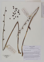
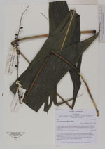
| Family | Arecaceae |
| Identification | Chamaedorea pauciflora Mart. |
| Determined by | H. Balslev |
| Identification qualifier | |
| Field notes | Solitary palm. Roots 20, 20cm long, 0.4cm thick. Stem 1m long, 2cm thick. Leaves 5 per stem; sheath 25cm; petiole 30cm, green; rachis 55cm; lamina 95 x 31cm, undivided. Inflorescence interfoliar; peduncular bracts 4, each 16cm long, soft, brown; peduncle 50cm long, 0.5cm thick, smooth; rachis 28cm long, unbranched; flowers sessile. Transect HB337-SU98. |
|