| Collector | Balslev, H. |
| Number | 7652 |
| Collected with | C. Grandez, G. Criollo, D. Pedersen, L. Stewart, I. Nicolajsen, W. Eiserhardt, D. Lindvig |
| Country | Peru |
| Subpart | Ucayali-Atalaya |
| County | |
| Locality | Just N of Río Toniromashi 6 km off Río Ucayali, 226 km S of Pucallpa (UTM 8855134 S; 613243 W). Tall rainforest on a spot of un-flooded restinga; dense understory of Geonoma brongniartii, G macrostachys acaulis. |
| Coordinates | 10° 21' 18.6'' S 73° 57' 56.3'' W |
| Minimum elevation (m) | 201 |
| Maximum elevation (m) | 0 |
| Start date | 2008/10/06 |
| End date | 0/00/00 |
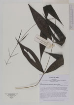
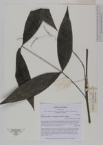
| Family | Arecaceae |
| Identification | Desmoncus mitis subsp. leptospadix (Mart.) A.J. Hend. |
| Determined by | H. Balslev |
| Identification qualifier | |
| Field notes | Cespitose liana. Stem 2.3m long, 0.5cm thick. Leaves 12 per stem; petiole 6cm, green; rachis 28cm; lamina 53 x 38cm; pinnae 3 per side, basal 18cm, middle 19cm, apical 19cm. Inflorescence interfoliar; peduncular bract 25cm long, inserted at the base; peduncle 10cm long, 0.1cm thick, smooth; rachis 12cm long, branched to 1st order; rachillae 4, 4cm long, 0.1cm thick; flowers sessile. Transect HB337-SU65. |
_HB7652_Desmoncus_mitis_leptospadix.jpg)
_HB7652_Desmoncus_mitis_leptospadix.jpg)
_HB7652_Desmoncus_mitis_leptospadix.jpg)
|