AAU Herbarium Database |
| New Search Modify Search |
| Collector | Balslev, H. |
| Number | 7651 |
| Collected with | C. Grandez, G. Criollo, D. Pedersen, L. Stewart, I. Nicolajsen, W. Eiserhardt, D. Lindvig |
| Country | Peru |
| Subpart | Ucayali-Atalaya |
| County | |
| Locality | Just N of Río Toniromashi 6 km off Río Ucayali, 226 km S of Pucallpa (UTM 8855208 S; 613320 W). Tall rainforest on a spot of un-flooded restinga; dense understory of Geonoma brongniartii, G macrostachys acaulis. |
| Coordinates | 10° 21' 16.2'' S 73° 57' 53.7'' W |
| Minimum elevation (m) | 229 |
| Maximum elevation (m) | 0 |
| Start date | 2008/10/06 |
| End date | 0/00/00 |
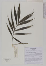
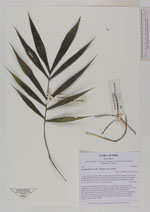
| Family | Arecaceae |
| Identification | Wendlandiella gracilis var. polyclada (Burret) A.J.Hend. |
| Determined by | Stauffer & Eychenne |
| Identification qualifier | |
| Field notes | Colonial, ascending palm. Stem 0.8m long, 0.4cm thick. Leaves 4 per stem, sheath 5cm, closed; petiole 8cm margined, green; rachis 8cm; lamina 17 x 17cm; pinnae 5 per side, basal 8cm, middle 11cm, apical 11cm. Inflorescence interfoliar; prophyll 3cm; peduncular bract 9cm long, soft, brown, inserted 4cm from the base; peduncle 13cm long, 0.2cm thick, smooth; rachis 1cm long, branched to 1st order; rachillae 4, 4.5cm long, 0.1cm thick; flowers sessile, orange. Transect HB337-SU47. |
_HB7651_Wendlandiella_gracilis_gracilis.jpg)
_HB7651_Wendlandiella_gracilis_gracilis.jpg)
_HB7651_Wendlandiella_gracilis_gracilis.jpg)
| |
 Other records of Wendlandiella gracilis var. polyclada Other records of Wendlandiella gracilis var. polycladaThe map displays only records from the Aarhus Herbarium Database. The records may not represent the full distribution of Wendlandiella gracilis var. polyclada |
| New Search Modify Search |