AAU Herbarium Database |
| New Search Modify Search |
| Collector | Balslev, H. |
| Number | 7649 |
| Collected with | C. Grandez, G. Criollo, D. Pedersen, L. Stewart, I. Nicolajsen, W. Eiserhardt, D. Lindvig |
| Country | Peru |
| Subpart | Ucayali-Atalaya |
| County | |
| Locality | Just N of Río Toniromashi 6 km off Río Ucayali, 226 km S of Pucallpa (UTM 8855229 S; 613385 W). Tall rainforest on a spot of un-flooded restinga; dense understory of Geonoma brongniartii, G macrostachys acaulis. |
| Coordinates | 10° 21' 15.5'' S 73° 57' 51.6'' W |
| Minimum elevation (m) | 217 |
| Maximum elevation (m) | 0 |
| Start date | 2008/10/06 |
| End date | 0/00/00 |
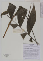
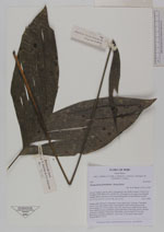
| Family | Arecaceae |
| Identification | Chamaedorea pinnatifrons (Jacq.)Oerst. |
| Determined by | H. Balslev |
| Identification qualifier | |
| Field notes | Solitary palm. Roots 20, 20cm long, 0.4cm thick. Stem 1m long, 1.5cm thick. Leaves 5 per stem; sheath 18cm, closed; petiole 38cm round, green; rachis 45cm; lamina 62 x 45cm; pinnae 5 per side, basal 26cm, middle 26cm, apical 24cm. Innfructescence infrafoliar; peduncular bract 19cm long, brown, inserted at the base; peduncle 39cm long, 0.4cm thick, smooth; rachis 3.5cm long, branched to 1st order; rachillae 6, 10cm long, 0.3cm thick; fruits sessile. Transect HB337-SU33. |
_HB7649_Chamaedorea_pinnatifrons.jpg)
_HB7649_Chamaedorea_pinnatifrons.jpg)
_HB7649_Chamaedorea_pinnatifrons.jpg)
_HB7649_Chamaedorea_pinnatifrons.jpg)
| |
| Display all 228 georeferenced records of Chamaedorea Chamaedorea pinnatifrons |
| New Search Modify Search |