| Collector | Balslev, H. |
| Number | 7647 |
| Collected with | C. Grandez, G. Criollo, D. Pedersen, L. Stewart, I. Nicolajsen, W. Eiserhardt, D. Lindvig |
| Country | Peru |
| Subpart | Ucayali-Atalaya |
| County | |
| Locality | Just N of Río Toniromashi 6 km off Río Ucayali, 226 km S of Pucallpa (UTM 8555367 S; 613500 W). Tall rainforest on a spot of un-flooded restinga; dense understory of Geonoma brongniartii, G macrostachys acaulis. |
| Coordinates | 10° 4' 31.6'' S 73° 55' 15.3'' W |
| Minimum elevation (m) | 198 |
| Maximum elevation (m) | 0 |
| Start date | 2008/10/06 |
| End date | 0/00/00 |
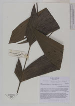
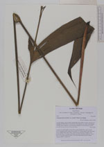
| Family | Arecaceae |
| Identification | Geonoma macrostachys var. acaulis (Mart.)A.J.Hend. |
| Determined by | H. Balslev |
| Identification qualifier | |
| Field notes | Acaulescent rosette-palm. Leaves 9 per rosette; sheath 23cm, open; petiole 47cm, margined, green; rachis 45cm; lamina 72 x 64cm; pinnae 3 per side, basal 40cm, middle 36cm, apical 34cm. Inflorescence interfoliar; prophyll 12cm; peduncular bract 31cm long, soft, brown, inserted at the base; peduncle 110cm long, 0.5cm thick, smooth; rachis 13cm long, unbranched; flowers sunken. Transect HB337-outside SU1. |
|