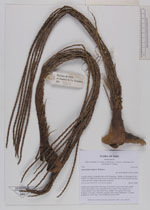
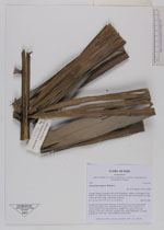
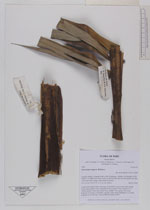
| Collector | Balslev, H. |
| Number | 7563 |
| Collected with | C. Grandez, G. Criollo, D. Pedersen, L. Stewart, I. Nicolajsen, W. Eiserhardt, D. Lindvig |
| Country | Peru |
| Subpart | Ucayali-Atalaya |
| County | |
| Locality | Fernando Estál on Río Schahuaya, 169km S of Pucallpa (UTM 8906971 S; 588005 W). Rain forest on the first hills after the flood plain less than 1 km west of the village; steep slopes in places. |
| Coordinates | 9° 53' 13.3'' S 74° 11' 50.3'' W |
| Minimum elevation (m) | 290 |
| Maximum elevation (m) | 0 |
| Start date | 2008/09/28 |
| End date | 0/00/00 |
| Family | Arecaceae |
| Identification | Oenocarpus mapora H.Karst. |
| Determined by | H. Balslev |
| Identification qualifier | |
| Field notes | Cespitose tree palm. Stem 12m long, 10cm thick. Leaves 8 per stem; sheath 67cm, open; petiole 32cm, margined, brown; rachis 292cm; lamina 311 x 145cm; pinnae 74 per side, basal 70cm, middle 73cm, apical 18cm long. Peduncle 7cm long, 3.5cm thick, smooth; rachis 54cm, branched to 1st order; rachillae 90, 54cm long. Transect HB328-outside SU99 |
_HB7563_Oenocarpus_mapora.jpg)
_HB7563_Oenocarpus_mapora.jpg)
|