| Collector | Balslev, H. |
| Number | 7555 |
| Collected with | C. Grandez, G. Criollo, D. Pedersen, L. Stewart, I. Nicolajsen, W. Eiserhardt, D. Lindvig |
| Country | Peru |
| Subpart | Ucayali-Atalaya |
| County | |
| Locality | Fernando Estál on Río Schahuaya, 169km S of Pucallpa (UTM 8907256 S; 588138 W). Rain forest on the first hills after the flood plain less than 1 km west of the village; steep slopes in places. |
| Coordinates | 9° 53' 4.1'' S 74° 11' 45.9'' W |
| Minimum elevation (m) | 242 |
| Maximum elevation (m) | 0 |
| Start date | 2008/09/28 |
| End date | 0/00/00 |
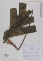
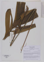
| Family | Arecaceae |
| Identification | Geonoma brongniartii Mart. |
| Determined by | H. Balslev |
| Identification qualifier | |
| Field notes | Solitary understory palm. Leaves 11; sheath 13cm, open; petiole 84cm, margined, green; rachis 67cm; lamina 95 x 60cm; pinnae 7 per side; basal 34cm, middle 40cm, apical 4cm. Peduncular bract 19cm, soft, brown; peduncle 37cm, 0.5cm thick; rachis 30cm, unbranched. Transect HB328-SU34 |
_HB7555_Geonoma_brongniartii.jpg)
_HB7555_Geonoma_brongniartii.jpg)
_HB7555_Geonoma_brongniartii.jpg)
_HB7555_Geonoma_brongnartii.jpg)
_HB7555_Geonoma_brongnartii.jpg)
|