| Collector | Balslev, H. |
| Number | 7549 |
| Collected with | C. Grandez, G. Criollo, D. Pedersen, L. Stewart, I. Nicolajsen, W. Eiserhardt, D. Lindvig |
| Country | Peru |
| Subpart | Ucayali-Atalaya |
| County | |
| Locality | Fernando Estál on Río Schahuaya, 169km S of Pucallpa (UTM 8907881 S; 590431 W). Rain forest on the first hills after the flood plain less than 1 km west of the village; steep slopes in places. |
| Coordinates | 9° 52' 43.5'' S 74° 10' 30.7'' W |
| Minimum elevation (m) | 190 |
| Maximum elevation (m) | 0 |
| Start date | 2008/09/28 |
| End date | 0/00/00 |
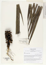
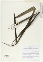
| Family | Arecaceae |
| Identification | Bactris concinna Mart. |
| Determined by | H. Balslev |
| Identification qualifier | |
| Field notes | Colonial understory palm. Stem 4m long, 4cm thick; spines 5cm long, black. Leaves 7 per stem; sheath 15cm, open; petiole 50cm, green; rachis 65cm; lamina 196 x 90cm; pinnae 44 per side, basal 50cm, middle 54cm, apical 30cm. Inflorescence-rachis 13cm long. Transect HB328-wayin |
_HB7549_Bactris_concinna.jpg)
_HB7549_Bactris_concinna.jpg)
_HB7549_Bactris_concinna.jpg)
_HB7549_Bactris_concinna.jpg)
_HB7549_Bactris_concinna.jpg)
_HB7549_Bactris_concinna.jpg)
_HB7549_Bactris_concinna.jpg)
_HB7549_Bactris_concinna.jpg)
_HB7549_Bactris_concinna.jpg)
_HB7549_Bactris_concinna.jpg)

|