AAU Herbarium Database |
| New Search Modify Search |
| Collector | Balslev, H. |
| Number | 7475 |
| Collected with | M. Kronborg, G. Criollo |
| Country | Peru |
| Subpart | Loreto |
| County | |
| Locality | Río Nanay ca. 30km. W of Santa Maria; ca. 80km. from outlet into Río Marañon. Right side of river going down stream. 82km W of Iquitos. Tropical rain forest on flood plain. Transect #304. (UTM 18M: 0613445;9576993). |
| Coordinates | 3° 49' 35.073'' S 73° 58' 41.844'' W |
| Minimum elevation (m) | 115 |
| Maximum elevation (m) | 0 |
| Start date | 2007/12/01 |
| End date | 0/00/00 |
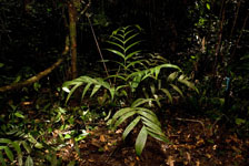
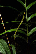
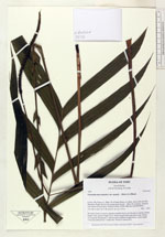
| Family | Arecaceae |
| Identification | Geonoma macrostachys var. acaulis (Mart.)A.J.Hend. |
| Determined by | |
| Identification qualifier | |
| Field notes | No stem. Crown: 9 leaves, petioles rounded below and flat above. Leaves: sheath length 14cm, petiole length 33cm, lamina length 59cm and 46cm wide. Pinnae: 14, regularly distributed. 1 inflorescence: peduncle length 60cm, rachis length 17cm and unbranched. 2 duplicates. Found in subunit 011. |
| |
| Display all 211 georeferenced records of Geonoma Geonoma macrostachys var. acaulis |
| New Search Modify Search |