AAU Herbarium Database |
| New Search Modify Search |
| Collector | Balslev, H. |
| Number | 7461 |
| Collected with | M. Kronborg, G. Criollo |
| Country | Peru |
| Subpart | Loreto |
| County | |
| Locality | Río Marañon ca. 10km. E. of Río Tigre outlet. N. side of river. 116km SW of Iquitos. Tropical rain forest on flood plain. Transect #301. (UTM 18M: 0613100;9505714). |
| Coordinates | 4° 28' 16.174'' S 73° 58' 50.054'' W |
| Minimum elevation (m) | 110 |
| Maximum elevation (m) | 0 |
| Start date | 2007/11/27 |
| End date | 0/00/00 |
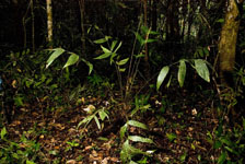
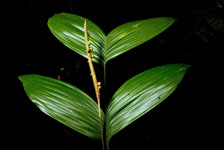
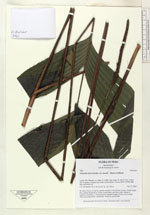
| Family | Arecaceae |
| Identification | Geonoma macrostachys var. acaulis (Mart.)A.J.Hend. |
| Determined by | |
| Identification qualifier | |
| Field notes | No stem. Crown: 13 leaves, petioles round in cross-section. Leaves: sheath length 9cm, petiole length 80cm, lamina length 60cm and 41cm wide. Pinnae: 8, regularly distributed. 1 infructescence: peduncle length 115cm, rachis length 16cm and unbranched. 2 duplicates. Found in subunit 002. |
| |
| Display all 211 georeferenced records of Geonoma Geonoma macrostachys var. acaulis |
| New Search Modify Search |