AAU Herbarium Database |
| New Search Modify Search |
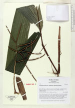
| Collector | Balslev, H. |
| Number | 7445 |
| Collected with | M. Kronborg, G. Criollo |
| Country | Peru |
| Subpart | Loreto |
| County | |
| Locality | Río Tigre ca. 60km from outlet into Río Marañon. 117km W of Iquitos. Tropical rain forest on hills with red clay. Transect #299. (UTM 18M: 0580924;9560055). |
| Coordinates | 3° 58' 47.758'' S 74° 16' 15.707'' W |
| Minimum elevation (m) | 135 |
| Maximum elevation (m) | 0 |
| Start date | 2007/11/26 |
| End date | 0/00/00 |
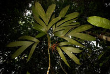
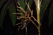
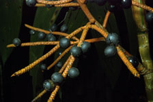
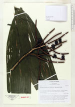
| Family | Arecaceae |
| Identification | Geonoma maxima var. chelidonura (Spruce)A.J.Hend. |
| Determined by | |
| Identification qualifier | |
| Field notes | Stem 290cm long and 2cm thick with a smooth surface. Crown: 9 leaves, petioles rounded below and flat above. Leaves: sheath length 14cm, petiole length 25cm, lamina length 83cm and 52cm wide. Pinnae: 4. 1 infructescence (orange peduncle/rachis and black fruits): peduncle length 7cm, rachis length 18cm and branched, rachillae length 5-12cm. 2 duplicates. Found in subunit 003. |
| |
| Display all 45 georeferenced records of Geonoma Geonoma maxima var. chelidonura |
| New Search Modify Search |