AAU Herbarium Database |
| New Search Modify Search |
| Collector | Balslev, H. |
| Number | 7351 |
| Collected with | M. Kronborg, G. Criollo |
| Country | Peru |
| Subpart | Loreto |
| County | |
| Locality | Río Ucayali E. of Requena (3km), 60 km. from Maranon. 148km SSW of Iquitos. Tropical rain forest on hills. Ouside transect #281. (UTM 18M: 0639444;9450306). |
| Coordinates | 4° 58' 18.941'' S 73° 44' 32.103'' W |
| Minimum elevation (m) | 117 |
| Maximum elevation (m) | 0 |
| Start date | 2007/11/12 |
| End date | 0/00/00 |
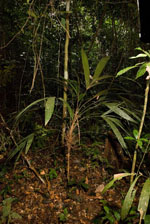
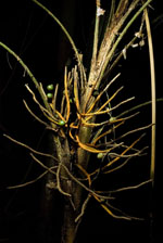
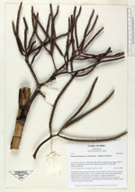
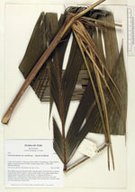
| Family | Arecaceae |
| Identification | Geonoma maxima var. chelidonura (Spruce)A.J.Hend. |
| Determined by | |
| Identification qualifier | |
| Field notes | Stem 350cm long and 2cm thick with a smooth surface. Crown:15 leaves, petioles rounded below and flat above. Leaves: sheath length 19cm, petiole length 60cm, lamina length 65cm and 83cm wide. Pinnae: 4, regularly distributed. 1 inflorescence (1 infructescence collected from another individual in the same subunit): peduncle length 11cm, rachis length 30cm and branched, rachillae length 14-17cm. Found near subunit 020. |
| |
| Display all 45 georeferenced records of Geonoma Geonoma maxima var. chelidonura |
| New Search Modify Search |