AAU Herbarium Database |
| New Search Modify Search |
| Collector | Balslev, H. |
| Number | 7323 |
| Collected with | M. Kronborg, G. Criollo |
| Country | Peru |
| Subpart | Loreto |
| County | |
| Locality | Río Tigre. Ca. 18 km E of inlet to Río Corrientes; left hand side going down river. 125km W of Iquitos. Tropical rain forest on hills with red clay. Transect #273. (UTM 18M: 0569576;9583935). |
| Coordinates | 3° 45' 50.365'' S 74° 22' 24.268'' W |
| Minimum elevation (m) | 175 |
| Maximum elevation (m) | 0 |
| Start date | 2007/11/02 |
| End date | 0/00/00 |
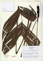
| Family | Arecaceae |
| Identification | Geonoma macrostachys var. acaulis (Mart.)A.J.Hend. |
| Determined by | |
| Identification qualifier | |
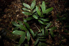
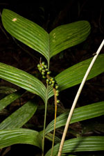
| Field notes | No stem except petioles. Crown: 10 leaves, petioles round in cross-section. Leaves: sheath length 10cm, petiole length 45cm, lamina length 52cm and 47cm wide. Pinnae: 8, regularly distributed. 1 infructescence (1 inflorescence): peduncle length 78cm, rachis length 13cm and unbranched. Found in subunit 046. |
| |
| Display all 211 georeferenced records of Geonoma Geonoma macrostachys var. acaulis |
| New Search Modify Search |