AAU Herbarium Database |
| New Search Modify Search |
| Collector | Balslev, H. |
| Number | 7265 |
| Collected with | M. Kronborg, G. Criollo |
| Country | Peru |
| Subpart | Loreto |
| County | |
| Locality | Río Tigre 19km SE of inlet Río Pucacura, 179km W of Iquitos. Tropical rain forest on hills with red clay. Transect #263. (UTM 18M: 0520279;9624036). |
| Coordinates | 3° 24' 5.065'' S 74° 49' 2.779'' W |
| Minimum elevation (m) | 170 |
| Maximum elevation (m) | 0 |
| Start date | 2007/10/28 |
| End date | 0/00/00 |
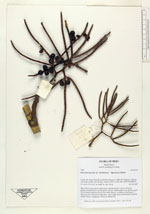
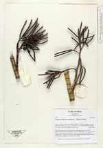
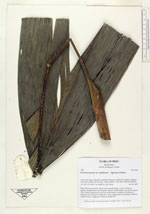
| Family | Arecaceae |
| Identification | Geonoma maxima var. chelidonura (Spruce)A.J.Hend. |
| Determined by | |
| Identification qualifier | |
| Field notes | Stem 355cm long and 2cm thick with a smooth surface. Crown: 10 leaves, petioles rounded below and flat above. Leaves: sheath length 11cm, petiole length 27cm, lamina length 84cm and 57cm wide. Pinnae: 4, regularly distributed. 3 infructescences: peduncle length 8cm, rachis length 18cm and branched, rachillae length 9-10cm. 2 duplicates. Found in subunit 001. |
| |
| Display all 45 georeferenced records of Geonoma Geonoma maxima var. chelidonura |
| New Search Modify Search |