| Collector | Balslev, H. |
| Number | 7154 |
| Collected with | G. Criollo, C. Grandez & T. Kristiansen |
| Country | Peru |
| Subpart | Loreto |
| County | |
| Locality | Río Napo, Quebrada Copalillo. Terra firme just above floodplain. Tall forest and secondary forest. (UTM 18m;0708840;9650068). Transect 244 |
| Coordinates | 3° 9' 51'' S 73° 7' 14'' W |
| Minimum elevation (m) | 0 |
| Maximum elevation (m) | 0 |
| Start date | 2006/10/16 |
| End date | 0/00/00 |
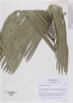
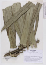
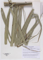
| Family | Arecaceae |
| Identification | Attalea insignis (Mart.)Drude |
| Determined by | |
| Identification qualifier | |
| Field notes | Acaulescent rosette of 6 erect lvs; each leaf 8.5 m long; petiole 3.5 m, blade 5 m long w. many pinnae in 30 groups of 2-6 leaflets per group, sticking out in different directions. Infructescence erect in axil of oldest leaf, peduncle 70 cm, fruit clumps 40x25 cm w. 40? fruits. Photo DSCN 2567-2573 |
|
 Other records of Attalea insignis