AAU Herbarium Database |
| New Search Modify Search |
| Collector | Balslev, H. |
| Number | 7123 |
| Collected with | V. Criollo, C. Grandez & T. Kristiansen |
| Country | Peru |
| Subpart | Loreto |
| County | |
| Locality | Río Mazan floodplain, ca. 30 km upstream from outlet, left bank going down river. Tall floodplain forest w. wet areas w. tangled vegetation. Holocene floodplain. (UTM 18m;0692310;9617986). Transect 239, 240 & 241 |
| Coordinates | 3° 27' 16'' S 73° 16' 8'' W |
| Minimum elevation (m) | 0 |
| Maximum elevation (m) | 0 |
| Start date | 2006/10/10 |
| End date | 0/00/12 |
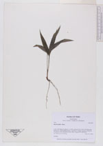
| Family | Arecaceae |
| Identification | Bactris bifida Mart. |
| Determined by | |
| Identification qualifier | |
| Field notes | Seedling |
| |
| Display all 26 georeferenced records of Bactris Bactris bifida |
| New Search Modify Search |