| Collector | Balslev, H. |
| Number | 7112 |
| Collected with | G. Criollo, C. Grandez & T. Kristiansen |
| Country | Peru |
| Subpart | Loreto |
| County | |
| Locality | Río Napo floodplain, ca. 1 km E of communidad Belo Horizonte, on Lake Suru Miraña. Flood plain forest on low laying ground in inner curve of oxbow lake; ground w. long dry levees and very swampy palm dominated low areas. Holocene flood plain. (UTM 18m;00711661;9621840). Transect 238 |
| Coordinates | 3° 25' 9'' S 73° 5' 41'' W |
| Minimum elevation (m) | 0 |
| Maximum elevation (m) | 0 |
| Start date | 2006/10/09 |
| End date | 0/00/09 |
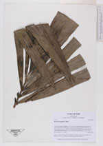
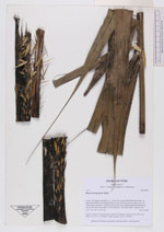
| Family | Arecaceae |
| Identification | Bactris brongniartii Mart. |
| Determined by | |
| Identification qualifier | |
| Field notes | Sterile voucher. Forming dense stands in wet places. Stems to 4 m tall, 4 cm thick. Lvs 5-6 w. very heavy, yellow spines. (AAU+AMAZ) |
|