AAU Herbarium Database |
| New Search Modify Search |
| Collector | Balslev, H. |
| Number | 7030 |
| Collected with | T. Kristiansen, D. K. Andersen, C. Grandez & G. Criollo |
| Country | Peru |
| Subpart | Loreto |
| County | |
| Locality | On Río Pintuyacu, 8 km upriver of the outlet of Río Chambira. Tall primary tropical rain forest, hilly, in parts rather open w. many natural gaps. Many tall columnar stems, parts w. dense undergrowth and few palms. (UTM (ca. 500 m SW from start of transect) 18M; 0627216;9595478). Transect # 226 |
| Coordinates | 3° 39' 32'' S 73° 51' 16'' W |
| Minimum elevation (m) | 120 |
| Maximum elevation (m) | 150 |
| Start date | 2006/03/20 |
| End date | 0/00/00 |
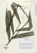
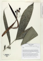
| Family | Arecaceae |
| Identification | Bactris |
| Determined by | |
| Identification qualifier | sp. |
| Field notes | Stem 30-40 cm; sheath 19 cm; petiole 70 cm; rachis 62 cm; blade 82x47 cm; pinnae 9 per side, spreading in one plane, filamentous, entire margins spiny. Spines on petiole to 7 cm, flattened, yellowish-dark. Peduncular bract 34 cm, w. few spines, to 6 cm; prophyll 14 cm; peduncle 22 cm; rachis 3 mm, at least 4 rachillae, to 2 mm diam.; fruit nearly spherical, obscurely rostrate; fibrous hard endocarp; relatively dry mesocarp, maybe juice sacs; hard endosperm |
| |
| Display all 106 georeferenced records of Bactris Bactris |
| New Search Modify Search |