AAU Herbarium Database |
| New Search Modify Search |
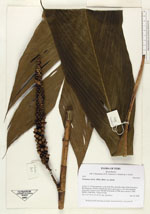
| Collector | Balslev, H. |
| Number | 7013 |
| Collected with | T. Kristiansen, D. K. Andersen, C. Grandez & G. Criollo |
| Country | Peru |
| Subpart | Loreto |
| County | |
| Locality | Ca. 32 km upstream, as the birds flies, from the outlet of Río Chambira, Rio Pintuyacu. Primary tropical rain forest, quite open w. few tall emergents, many hills. Transect starts 500 NE of the point. (UTM (river entrance) 18M; 0602971;9607044). Transect # 224 |
| Coordinates | 3° 33' 16'' S 74° 4' 22'' W |
| Minimum elevation (m) | 120 |
| Maximum elevation (m) | 150 |
| Start date | 2006/03/18 |
| End date | 0/00/00 |
| Family | Arecaceae |
| Identification | Geonoma stricta var. stricta (Poit.)Kunth |
| Determined by | |
| Identification qualifier | |
| Field notes | |
| |
| Display all 90 georeferenced records of Geonoma Geonoma stricta var. stricta |
| New Search Modify Search |