| Collector | Balslev, H. |
| Number | 7012 |
| Collected with | T. Kristiansen, D. K. Andersen, C. Grandez & G. Criollo |
| Country | Peru |
| Subpart | Loreto |
| County | |
| Locality | Ca. 32 km upstream, as the birds flies, from the outlet of Río Chambira, Rio Pintuyacu. Primary tropical rain forest, quite open w. few tall emergents, many hills. Transect starts 500 NE of the point. (UTM (river entrance) 18M; 0602971;9607044). Transect # 224 |
| Coordinates | 3° 33' 16'' S 74° 4' 22'' W |
| Minimum elevation (m) | 120 |
| Maximum elevation (m) | 150 |
| Start date | 2006/03/18 |
| End date | 0/00/00 |
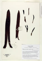
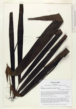
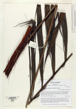
| Family | Arecaceae |
| Identification | Pholidostachys synanthera subsp. robusta (Trail) A.J.Hend. |
| Determined by | |
| Identification qualifier | |
| Field notes | Stem solitary, 5 m tall, 5 cm diam. Lvs 10-15 in crown; sheath 25 cm; petiole 75 cm; rachis 70 cm; lamina 105x55; pinnae 12 per side, regularly inserted, spreading in one plane, all pinnae of almost same size. Inflorescence interfoliar, becoming infrafoliar, branching to 2nd order. Peduncular bract 25 cm; prophyll 30 cm; peduncle 45 cm; rachillae 23-28, to 30 cm |
|
 Other records of Pholidostachys synanthera subsp. robusta