| Collector | Balslev, H. |
| Number | 6952 |
| Collected with | T. Kristiansen, D. K. Andersen, C. Grandez & G. Criollo |
| Country | Peru |
| Subpart | Loreto |
| County | |
| Locality | Río Tahuayo, Quebrada Blanca, ca. 5 km upstream from 7 de Junio (Diamante), ca. 70 km S of Iquitos . Quarternary river terrace w. tall forest and dense understory w. many palms, undulatinf (not hilly terrain). (UTM 18M;706357;9515216). Transect # 212 |
| Coordinates | 4° 23' 0'' S 73° 8' 25'' W |
| Minimum elevation (m) | 120 |
| Maximum elevation (m) | 150 |
| Start date | 2006/02/21 |
| End date | 0/00/00 |
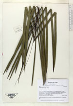
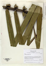
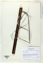
| Family | Arecaceae |
| Identification | Attalea microcarpa Mart. |
| Determined by | |
| Identification qualifier | |
| Field notes | Acaulescent rosette of 6 lvs. Petiole 70 cm; blade 590x200 cm w. 112 pinnae per side |

|
 Other records of Attalea microcarpa