AAU Herbarium Database |
| New Search Modify Search |
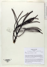
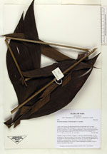
| Collector | Balslev, H. |
| Number | 6946 |
| Collected with | T. Kristiansen, D. K. Andersen, C. Grandez & G. Criollo |
| Country | Peru |
| Subpart | Loreto |
| County | |
| Locality | Río Tahuayo, Quebrada Blanca between San Pedro and 7 de Junio (Diamante), about 70 km S of Iquitos . Tropical rain forest with many tall stems and dense understory w. many palms; level terrain w. some wet low areas between dry soils. Quarternary terrace. (UTM 18M;700546;9517814). Transect # 211 |
| Coordinates | 4° 21' 36'' S 73° 11' 34'' W |
| Minimum elevation (m) | 120 |
| Maximum elevation (m) | 150 |
| Start date | 2006/02/20 |
| End date | 0/00/00 |
| Family | Arecaceae |
| Identification | Geonoma maxima var. maxima (Poit.)Kunth |
| Determined by | |
| Identification qualifier | |
| Field notes | Cespitose, stems to 4 m tall, 3 cm thick, w. obvious, smooth internodes. Lvs 14, spreading in a flat crown; petiole 70 cm, green w. brown tomentum; blade 95x50 cm; pinnae 10-12 per side, sigmoid, 2-9 cm wide w. 2-5 nerves, but appearence of the blade is regular pinnate w. the pinnae evenly inserted in one plane. Inflorescence infrafoliar, first green w. brown tomentum, becomming yellow at anthesis, branched to 2nd order |
| |
| Display all 43 georeferenced records of Geonoma Geonoma maxima var. maxima |
| New Search Modify Search |