| Collector | Balslev, H. |
| Number | 6945 |
| Collected with | T. Kristiansen, D. K. Andersen, C. Grandez & G. Criollo |
| Country | Peru |
| Subpart | Loreto |
| County | |
| Locality | Río Tahuayo, Quebrada Blanca between San Pedro and 7 de Junio (Diamante), about 70 km S of Iquitos . Tropical rain forest with many tall stems and dense understory w. many palms; level terrain w. some wet low areas between dry soils. Quarternary terrace. (UTM 18M;700546;9517814). Transect # 211 |
| Coordinates | 4° 21' 36'' S 73° 11' 34'' W |
| Minimum elevation (m) | 120 |
| Maximum elevation (m) | 150 |
| Start date | 2006/02/20 |
| End date | 0/00/00 |
| Family | Arecaceae |
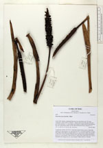
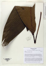
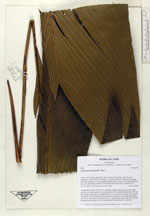
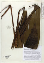
| Identification | Geonoma macrostachys Mart. |
| Determined by | |
| Identification qualifier | |
| Field notes | Acaulescent, rosettes of 5-6 lvs w. interfoliar spicate inflorescences. Somewhat similar to G. macrostachys var. macrostachys, but w. pronounced petiole to 80 cm long; blade wider relative to length, than in var. macrostachys; blade sides parallel in distal part of leaf. Peduncle relatively short and thick and rachilla much thicker than in var. macrostachys; infructescence w. green fruits, rachis dark red w. brown tomentum (not orange as in var. macrostachys). Blade entire or ± divided |
|