| Collector | Balslev, H. |
| Number | 6944 |
| Collected with | T. Kristiansen, D. K. Andersen, C. Grandez & G. Criollo |
| Country | Peru |
| Subpart | Loreto |
| County | |
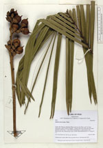
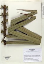
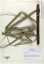
| Locality | Río Tahuayo, Quebrada Blanca between San Pedro and 7 de Junio (Diamante), about 70 km S of Iquitos . Tropical rain forest with many tall stems and dense understory w. many palms; level terrain w. some wet low areas between dry soils. Quarternary terrace. (UTM 18M;700546;9517814). Transect # 211 |
| Coordinates | 4° 21' 36'' S 73° 11' 34'' W |
| Minimum elevation (m) | 120 |
| Maximum elevation (m) | 150 |
| Start date | 2006/02/20 |
| End date | 0/00/00 |
| Family | Arecaceae |
| Identification | Attalea microcarpa Mart. |
| Determined by | |
| Identification qualifier | |
| Field notes | Acaulescent. Lamina 490x180 cm; petiole 30 cm; 105 pinnae per side |
|
 Other records of Attalea microcarpa