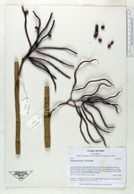
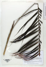
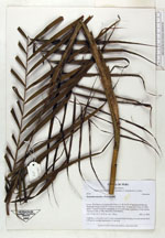
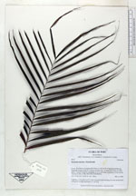
| Collector | Balslev, H. |
| Number | 6918 |
| Collected with | T. Kristiansen, D. K. Andersen, C. Grandez & G. Criollo |
| Country | Peru |
| Subpart | Loreto |
| County | |
| Locality | Río Nanay at a point called Grau (ca. 90 km W of Iquitos) and then up Quebrada Pizzaro to the N 3.5 km as the bird flies. Primary rain forest on white sands ("varreal") with few emergents to 30 m and dense understory of erect poles. Transect # 208. (UTM 18M;0582159;9598096) |
| Coordinates | 3° 38' 8'' S 74° 15' 36'' W |
| Minimum elevation (m) | 120 |
| Maximum elevation (m) | 0 |
| Start date | 2006/02/14 |
| End date | 0/00/00 |
| Family | Arecaceae |
| Identification | Geonoma maxima (Poit.)Kunth |
| Determined by | |
| Identification qualifier | (var. “minima”) |
| Field notes | Cespitose, to 3 m tall; lvs 6-11 erect and graciously bending out; stem pencil-thick with green, smooth internodes to 4 cm long |
|
 Other records of Geonoma maxima