AAU Herbarium Database |
| New Search Modify Search |
| Collector | Balslev, H. |
| Number | 6917 |
| Collected with | T. Kristiansen, D. K. Andersen, C. Grandez & G. Criollo |
| Country | Peru |
| Subpart | Loreto |
| County | |
| Locality | Río Nanay at a point called Grau (ca. 90 km W of Iquitos) and then up Quebrada Pizzaro to the N 3.5 km as the bird flies. Primary rain forest on white sands ("varreal") with few emergents to 30 m and dense understory of erect poles. Transect # 208. (UTM 18M;0582159;9598096) |
| Coordinates | 3° 38' 8'' S 74° 15' 36'' W |
| Minimum elevation (m) | 120 |
| Maximum elevation (m) | 0 |
| Start date | 2006/02/14 |
| End date | 0/00/00 |
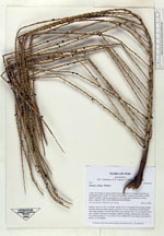
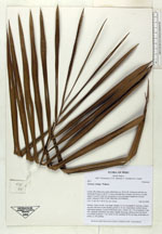
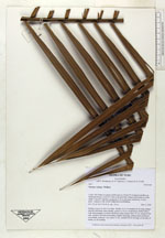
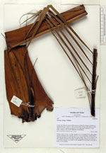
| Family | Arecaceae |
| Identification | Euterpe catinga Wallace |
| Determined by | |
| Identification qualifier | |
| Field notes | Solitary; stem 4 m tall, 4 cm diam. distally; lvs 8; crownshaft 45 cm long, orange, smooth with black scales distally; petiole to 10 cm, round below, hollow above, with sharp margins, covered with black scales; lamina 160 x 70 cm; pinnae 47 per side, regularly inserted in one plane, slightly drooping; inflorescence just below crownshaft; peduncle 7 cm, rachis 25 cm, rachillae 40-45 cm long, on all sides of rachis, ca. 60 rachillae |
| |
 Other records of Euterpe catinga Other records of Euterpe catingaThe map displays only records from the Aarhus Herbarium Database. The records may not represent the full distribution of Euterpe catinga |
| New Search Modify Search |