AAU Herbarium Database |
| New Search Modify Search |
| Collector | Balslev, H. |
| Number | 6916 |
| Collected with | T. Kristiansen, D. K. Andersen, C. Grandez & G. Criollo |
| Country | Peru |
| Subpart | Loreto |
| County | |
| Locality | Río Nanay at a point called Grau (ca. 90 km W of Iquitos) and then up Quebrada Pizzaro to the N 3.5 km as the bird flies. Primary rain forest on white sands ("varreal") with few emergents to 30 m and dense understory of erect poles. Transect # 208. (UTM 18M;0582159;9598096) |
| Coordinates | 3° 38' 8'' S 74° 15' 36'' W |
| Minimum elevation (m) | 120 |
| Maximum elevation (m) | 0 |
| Start date | 2006/02/14 |
| End date | 0/00/00 |
| Family | Arecaceae |
| Identification | Mauritiella aculeata (Kunth)Burret |
| Determined by | |
| Identification qualifier | |
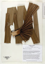
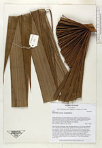
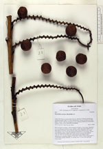
| Field notes | Stem 10 m tall, 9 cm diam., with root spines all along, to 10 cm long ± branched. Lvs 4, distichously inserted in some, spirally in other individuals: sheath 15 cm, open almost to the base; petiole 200 cm, round, green with brown dots; blade costa-palmate; costa 12 cm; leaf segments 60 fused for 9-15 cm at base, 120 cm long, dark green above, lighter green below (but not silvery), each segment 1-nerved, with 5-10 mm long spines along margins and midnerve above, infructescence intrafoliar; peduncle 70 cm with 11 bracts; rachis 110 cm with 2 x 15 distichous, primary branches, 25 cm long; fruit 3 x 4 cm, with small light brown scales |
| |
 Other records of Mauritiella aculeata Other records of Mauritiella aculeataThe map displays only records from the Aarhus Herbarium Database. The records may not represent the full distribution of Mauritiella aculeata |
| New Search Modify Search |