| Collector | Balslev, H. |
| Number | 6877 |
| Collected with | T. Kristiansen, D. K. Andersen, C. Grandez & G. Criollo |
| Country | Peru |
| Subpart | Loreto |
| County | |
| Locality | Río Nanay, Communidad Diamante Azul above confluence with Río Pintuyaco. Tall tropical rain forest with many tall columnar trunks on terra firme. Pebas formation. Transect # 205. (UTM 18M;0635589;9570970) |
| Coordinates | 3° 52' 50'' S 73° 46' 43'' W |
| Minimum elevation (m) | 0 |
| Maximum elevation (m) | 0 |
| Start date | 2006/02/11 |
| End date | 0/00/00 |
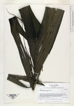
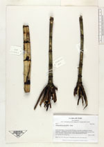
| Family | Arecaceae |
| Identification | Chamaedorea pauciflora Mart. |
| Determined by | |
| Identification qualifier | |
| Field notes | Stem 1 m; lvs 5; stem green with prominent nodes and internodes |
|