AAU Herbarium Database |
| New Search Modify Search |
| Collector | Balslev, H. |
| Number | 6785 |
| Collected with | T. Kristiansen, D. K. Andersen, C. Grandez & G. Criollo |
| Country | Peru |
| Subpart | Loreto |
| County | |
| Locality | Iquitos-Nauta rd. km 31.5 and then a few km to the NW of the road. Tropical rain forest on mosaic of white sand and clay soils, varying from tall diverse to low and species poor |
| Coordinates | 4° 0' .1'' S 73° 26' 36'' W |
| Minimum elevation (m) | 120 |
| Maximum elevation (m) | 0 |
| Start date | 2006/01/31 |
| End date | 0/00/00 |
| Family | Arecaceae |
| Identification | Attalea |
| Determined by | |
| Identification qualifier | |
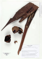
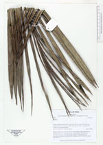
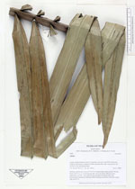
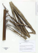
| Field notes | Solitary, acaulescent; crown of 10-12 lvs in spreading rosette; petiole 190 cm, blade 3.5x2.3 m, w. 112 pinnae per side, all in one plane. Infructescence interfoliar, erect 60++ cm, rachis 20 cm, all fruits on abaxial side, fruit mucronulate, tomentose, endocarp fibres forming an unevenly thick but closed ring; seeds 2-3 |
| |
 Other records of Attalea Other records of AttaleaThe map displays only records from the Aarhus Herbarium Database. The records may not represent the full distribution of Attalea |
| New Search Modify Search |