AAU Herbarium Database |
| New Search Modify Search |
| Collector | Balslev, H. |
| Number | 6510 |
| Collected with | |
| Country | Ecuador |
| Subpart | ZAMORA-CHINCHIPE |
| County | |
| Locality | Road Loja-Zamora km 27,5. Dense vegetation on very steep rocky walls towards a small stream. |
| Coordinates | 3° 38' S 79° 3' W |
| Minimum elevation (m) | 2000 |
| Maximum elevation (m) | 2000 |
| Start date | 2000/08/05 |
| End date | 2000/08/05 |
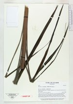
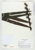
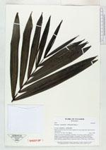
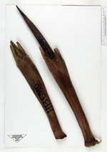
| Family | Arecaceae |
| Identification | Prestoea acuminata var. acuminata (Willd.)H.E.Moore |
| Determined by | H. Balslev |
| Identification qualifier | |
| Field notes | "Stem 3-4 m tall, 6 cm diameter; internodes 3-8 cm long, smooth, light brown; sheaths 50 cm long, open, not forming a crownshaft, with fibrous reticulate margins; petiole 20 cm; blade 220x80 cm with 50 pinnae per side in one plane. Buds infrafoliar, prophyll 32x6 cm, bicarinate. Bract to 50 cm long, round, brown." |
| |
| Display all 36 georeferenced records of Prestoea Prestoea acuminata var. acuminata |
| New Search Modify Search |