AAU Herbarium Database |
| New Search Modify Search |
| Collector | Balslev, H. |
| Number | 62520 |
| Collected with | Galeano, G. & Bernal, R. & Bergmann, B. |
| Country | Ecuador |
| Subpart | EL ORO |
| County | |
| Locality | West andean slopes near the coastal plain ca. 30 km N of Machala (Rio Bonito) along Guayaquil road and 6 km to the east along trail. Tropical humid forest on steep slopes. |
| Coordinates | 3° 11' S 79° 41' W |
| Minimum elevation (m) | 300 |
| Maximum elevation (m) | 300 |
| Start date | 1987/05/14 |
| End date | 1987/05/14 |
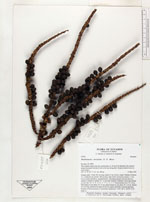
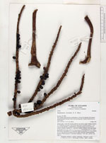
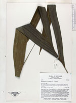
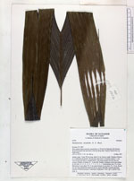
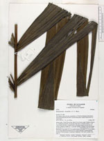
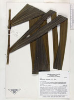
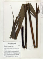
| Family | Arecaceae |
| Identification | Pholidostachys dactyloides H. E. Moore |
| Determined by | |
| Identification qualifier | |
| Field notes | Solitary palm. Trunk 390 cm long, diam 6.5 cm, brown, rough. Number of leaves 12. Leafsheath and petiole 140 cm long, diam below lowermost pinnae 1.7 cm. Cross section flat above, rounded below, with sharp margins between the two surfaces. Number of pinnae 10 - 11 per side. Number of primary nerves per pinnae on one side: 10 - 4 - 4 - 5 - 4 - 7 - 7 - 5 - 3 - 5 - 7. Basal pinnae erect 75 x 8 cm. Mid pinnae in one plane 70 x 9 cm, apical pinnae in one plane 55 x 10 cm. Rachis 155 cm long, flattened for basal for 60 cm, angled adaxially, rounded abaxially. Number of infructescences 2, interfoliar. Duplicates: AAU, QCA, QCNE, COL. Dupl. 6. |

| |
 Other records of Pholidostachys dactyloides Other records of Pholidostachys dactyloidesThe map displays only records from the Aarhus Herbarium Database. The records may not represent the full distribution of Pholidostachys dactyloides |
| New Search Modify Search |