AAU Herbarium Database |
| New Search Modify Search |
| Collector | Balslev, H. |
| Number | 62486 |
| Collected with | Galeano, G. & Bernal, R. & Bergmann, B. |
| Country | Ecuador |
| Subpart | NAPO |
| County | |
| Locality | Quito - Lago Agrio road 2 km west of Baeza. Remnants of montane forest along road, secondary forest. |
| Coordinates | 0° 27' S 77° 55' W |
| Minimum elevation (m) | 1970 |
| Maximum elevation (m) | 1970 |
| Start date | 1987/05/05 |
| End date | 1987/05/05 |
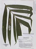
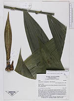
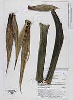
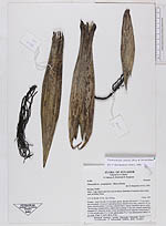
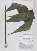
| Family | Arecaceae |
| Identification | Chamaedorea linearis (Ruiz & Pav.)Mart. |
| Determined by | Borchsenius, F. (AAU), 1996. |
| Identification qualifier | |
| Field notes | Solitary - stem 4 m tall, 3.5 cm thick, green, smooth, internodes 9 -11 cm below the crownshaft. Crown of 4 spreading leaves; sheath 64 cm long, closed for 43 cm, green, smooth; petiole 5 cm long, rounded below, clearly channelled above; rachis 140 cm long, rounded below, angled above; pinnae 17 per side, slightly channelled, arranged in V along the rachis, evenly distributed but not opposite; basal pinna 47 x 5 cm; middle pinna 51 x 12 cm; apical pinna 33 x 7 cm. Inflorescence buds 2 -4 per node. |
| |
| Display all 110 georeferenced records of Chamaedorea Chamaedorea linearis |
| New Search Modify Search |