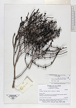
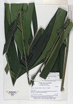
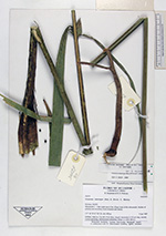
| Collector | Balslev, H. |
| Number | 62475 |
| Collected with | Bergmann, B. & Pedersen, H. B. |
| Country | Ecuador |
| Subpart | NAPO |
| County | |
| Locality | Misuahalli 2 - 3 km north east of the village (east of Rio Misuahalli. Patches of primary and secondary forest (tropical rain forest). |
| Coordinates | 1° 3' S 77° 34' W |
| Minimum elevation (m) | 450 |
| Maximum elevation (m) | 450 |
| Start date | 1987/04/03 |
| End date | 1987/04/03 |
| Family | Arecaceae |
| Identification | Geonoma interrupta subsp. interrupta Mart. |
| Determined by | A. Henderson |
| Identification qualifier | |
| Field notes | Solitary, stem ca. 5 m tall, 4 cm diam, ringed, internodes 2.5-3 cm long, smooth. Leaves spreading. Inflorescence infrafoliar. |
|
 Other records of Geonoma interrupta subsp. interrupta