AAU Herbarium Database |
| New Search Modify Search |
| Collector | Balslev, H. |
| Number | 62439 |
| Collected with | Bergmann, B. & Pedersen, H. B. |
| Country | Ecuador |
| Subpart | TUNGURAHUA |
| County | |
| Locality | Baños - Puyo road km 19. Dense montane forest on steep slopes along the road. |
| Coordinates | 1° 25' S 78° 18' W |
| Minimum elevation (m) | 1600 |
| Maximum elevation (m) | 1600 |
| Start date | 1987/03/24 |
| End date | 1987/03/24 |
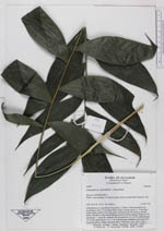
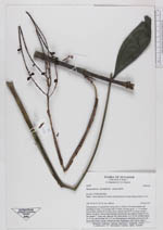
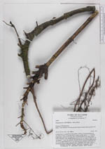
| Family | Arecaceae |
| Identification | Chamaedorea pinnatifrons (Jacq.)Oerst. |
| Determined by | |
| Identification qualifier | cf. |
| Field notes | . Solitary. Stem procumbent and ascending or erect, 2.5 cm long with 23 nodes, smooth, green, 1- 1.5 cm thick. Leaves three; sheath 22 cm long, green, smooth; petiole 23 cm long, rounded below, flat above, with rounded margins between the two surfaces; blade 56 x 29 cm; pinnae 7 - 8 per side, sigmoid, soft, basal pinnae 14 x 2.8 cm, middle pinnae 19 x 6 cm, apical pinnae 16 x 5.5 cm. Infructescence infrafoliar, horizontal with horizontal pinnae, orange with green fruits. Duplicates: AAU, QCA. Dupl. 2. |
| |
| Display all 228 georeferenced records of Chamaedorea Chamaedorea pinnatifrons |
| New Search Modify Search |