AAU Herbarium Database |
| New Search Modify Search |
| Collector | Balslev, H. |
| Number | 62423 |
| Collected with | Bergmann, B. & Pedersen, H. B. |
| Country | Ecuador |
| Subpart | PASTAZA |
| County | |
| Locality | Headwater of Rio Bobonaza 10-20 km southeast of Puyo. Tropical rain forest on Andean foot hills, steep slopes. |
| Coordinates | 1° 32' S 77° 48' W |
| Minimum elevation (m) | 730 |
| Maximum elevation (m) | 730 |
| Start date | 1987/03/21 |
| End date | 1987/03/21 |
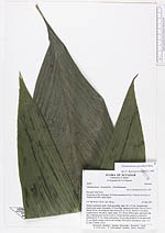
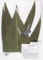
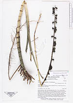
| Family | Arecaceae |
| Identification | Chamaedorea pauciflora Mart. |
| Determined by | Borchsenius, F. (AAU), 1996. |
| Identification qualifier | |
| Field notes | Solitary understory palm. Stem ascending, open, 20 x 1.5 cm, conspicuously ridged at the nodes, internodes 1.5-2 cm long, tapering to the base. Leaves 8 erect. Sheath 30 cm, encircling the other leaves for ca. 10 cm. Petiole 0.7 cm thick, rounded below, flat above. Blade entire, 70 x 30 cm, bifid at apex, tapering to the base. Infructescence in axil of leaf no. 4 from the base, peduncle enclosed in leafsheath for 25 cm, simple unbranched, 70 cm long; peduncle 35 cm and rachis 35 cm. Rachis orange ovate in curs seeting. Fruits green (immature) ovate 1.3 x 0.9 cm. |
| |
| Display all 97 georeferenced records of Chamaedorea Chamaedorea pauciflora |
| New Search Modify Search |