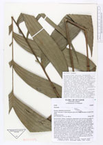
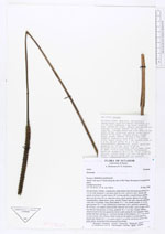
| Field notes | On terra firme. Solitary. Acaulescent, subterranean stem horizontal ascending, 6 x 3.5 cm with numerous 1 mm thick roots all over. Leaves 8, erect. Sheath and petiole not distinct in outer leaves, 90 cm long together, rounded below and flat above on the lower 20 cm, otherwise terete, green smooth. Rachis 45 cm long, rounded below, ridged above, green, smooth. Pinnae 6 per side, sigmoid, unequally wide with 1-8 primary veins, basal pinnae 35 x 7 cm, middle pinnae 33 x 6 cm, apical pinnae 30 x 7.5 cm. Inflorescence interfoliar, erect, spikelike; peduncle ca. 90 cm long, very slightly dorsiventrally flattened, red at abse, green at apex, with a fine fibrous furfuraceous covering, prophyll 10 x 1 cm, thin, slightly fibrous, closed except for the two apical cm where it splits along the two marginal ridges, peduncular bract inserted ca. 1 cm from the base of the peduncle, 22 x 1 cm, round in cross section, thin, fibrous, closed except for the apical 4 cm that open by a lateral split. Rachis 20 x 1 cm, green, apical 2 cm sterile and drawn out to a fine point, green, verruculose from unopened flowerbuds. |