AAU Herbarium Database |
| New Search Modify Search |
| Collector | Balslev, H. |
| Number | 62101 |
| Collected with | Henderson, A. & Borchsenius, F. |
| Country | Ecuador |
| Subpart | ESMERALDAS |
| County | |
| Locality | Road from Ibarra to Lita, 8-11 km beyond Lita. |
| Coordinates | 0° 5' N 78° 27' W |
| Minimum elevation (m) | 800 |
| Maximum elevation (m) | 900 |
| Start date | 1986/05/14 |
| End date | 1986/05/16 |
| Family | Arecaceae |
| Identification | Geonoma cuneata var. cuneata H.Wendl. ex Spruce |
| Determined by | F. Skov |
| Identification qualifier | |
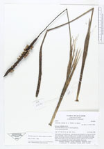
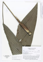
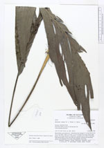
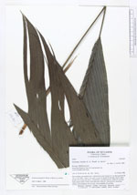
| Field notes | Stem solitary, procumbent and - subterranean and rooting for 1 m, then erect for 20 cm, 2.5 cm diam., nodes 2 cm apart. Leaves 8; sheath 10 cm long, brown, open; petiole 30 cm long, flat above, round below, greenish brown; rachis 45 cm long; blade almost entire or more often split into segments. Inflorescence interfoliar, spicate, erect; peduncle 40 cm long; rachis purplish, 16 cm long. |
| |
| Display all 31 georeferenced records of Geonoma Geonoma cuneata var. cuneata |
| New Search Modify Search |