AAU Herbarium Database |
| New Search Modify Search |
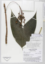
| Collector | Balslev, H. |
| Number | 62099 |
| Collected with | Henderson, A. & Borchsenius, F. |
| Country | Ecuador |
| Subpart | ESMERALDAS |
| County | |
| Locality | Road from Ibarra to Lita, 8-11 km beyond Lita. |
| Coordinates | 0° 5' N 78° 27' W |
| Minimum elevation (m) | 800 |
| Maximum elevation (m) | 900 |
| Start date | 1986/05/14 |
| End date | 1986/05/16 |
| Family | Arecaceae |
| Identification | Geonoma lanata A.J. Hend., Borchs. & Balslev |
| Determined by | A.Henderson |
| Identification qualifier | |
| Field notes | Stem soliatry, erect, brown, 50 cm long, 1 cm diam, with prominent nodes 2 cm apart. Leaves 9; sheath 6 cm long, closed, green; petiole 18 cm long, green, rounded below, flat above; blade entire. Infructescence infrafoliar, pendulous; peduncle 12 cm long, becoming reddish above; rachis 4 cm long, reddish, rachillae 4, 10 cm long, reddish. Immature fruits green apiculate. |
| |
 Other records of Geonoma lanata Other records of Geonoma lanataThe map displays only records from the Aarhus Herbarium Database. The records may not represent the full distribution of Geonoma lanata |
| New Search Modify Search |