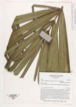
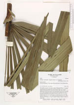
| Field notes | Stem solitary, 12 m tall, 12 cm diam. at apex, leaning, internodes 2 - 3 cm long at top, dark grey, smooth, covered with bryophytes and lichens. Leaves 5, spreading, sheaths forming a crownshaft 150 cm long, swollen at base, grey, smooth (purple-grey on inner leaves); petiole 30 cm long, grey-green, terete except for base toward sheath where it is flac above, rachis 290 cm long, rounded below, triangular above; pinnae spreading in many planes and opposite or alternate; 25 per side, divided into (from base) 4-6-79-9-8-8-8-8-8-7-7-6-7-7-6-6-6-1-3-2-1-1-1-1; apical pinna not entire, 13 x 1.5 cm; basal segment of middle pinna 130 x 8 cm; basal segment of basal pinna 37 x 1 cm. Inflorescence buds not inserted on rim; number varies from 3-9-3-4 (lateral of 3 male) (central of 3 female), staminate rachillae not coiled in bud. |
 Other records of Wettinia fascicularis