AAU Herbarium Database |
| New Search Modify Search |
| Collector | Balslev, H. |
| Number | 62081 |
| Collected with | Henderson, A. & Borchsenius, F. |
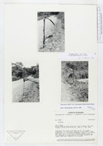
| Country | Ecuador |
| Subpart | NAPO |
| County | |
| Locality | 30 km north of Tena along the road to Baeza. Cut over forest. |
| Coordinates | 0° 47' S 77° 51' W |
| Minimum elevation (m) | 1000 |
| Maximum elevation (m) | 1000 |
| Start date | 1986/05/03 |
| End date | 1986/05/03 |
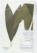
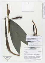
| Family | Arecaceae |
| Identification | Geonoma stricta var. piscicauda (Dammer)A.J.Hend. |
| Determined by | H. Balslev |
| Identification qualifier | |
| Field notes | Cespitose (?). Stem 1 cm diam, up to 1.5 m long, procumbent and ascending, rooting at the nodes, light brown with c. 5 cm long internodes. Leaves 7 (/+) along the upper part of the stem. Inflorescences erect in bud, droopig at flowering and fruiting. Peduncle and rachis deep red, immature fruits green. |
| |
| Display all 75 georeferenced records of Geonoma Geonoma stricta var. piscicauda |
| New Search Modify Search |