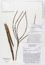
| Field notes | Stem 10-40 cm, solitary, procumbent or ascending, 3 cm wide, light brown, with densely inserted leafscars, uneven. Leaves 9, erect, sheath and petiole not distinct, sheath open to the base in outer leaves, ca. 10 cm long. Petiole 63 cm long, rounded below, flat above with sharp margins, green smooth below, with whitish tomentum above. Rachis 50 cm long, rounded below, ridged above, green with brownish tomentum below, green smooth above. Pinnae 7 per side, irregularly inserted along the rachis, of unequal width, slightly sigmoid, long acuminate, all in one plane, basal pinna 34 x 5.5 cm, middle pinna 36 x 5.5 xm, upper pinna 34 x 7 cm. Inflorescence interfoliar, erect, green at first becoming red. Peduncle 30 cm long, rounded and slightly dorsiventrally flattened, prophyll 19 x 1.5 cm, peduncular bract inserted 3 cm from the base of peduncle, 19 cm long, linear, ca. 1 cm wide. Rachis ca. 5 cm long, rounded, red. Rachillae 6, rounded, 18-25 cm long, red. Fruits green at first, slightly elongate. Siona: "pui" (Victoriana). Quichua: "Huasi-panga" (=House-leaf). Used as thatch for houses. |
 Other records of Geonoma longepedunculata