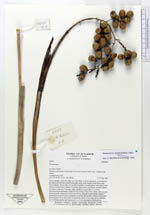
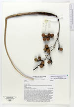
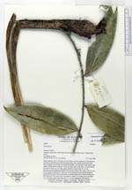
| Field notes | Stem scandent, up to 8 m long, ca. 2 cm diam.; Leaves numerous, not distichous, persistent and not abscising but decaying along stem; sheath closed below and above petiole, 50 cm long, (12 cm above petiole), covered above with short 4 mm spines, smooth below; petiole 7 cm long, spiny above and below, rounded below, flat above; rachis ca. 1 m long, spiny; pinnae ca. 8 per side, 25 x 6 cm. Infructescences pendulous; peduncle 60 cm long, 8 mm wide, white, spiny at apex, dorsoventrally compressed, with lower 40 cm included in leaf sheath; prophyll inserted 40 cm above base of peduncle (or adnate below this?), absent; peduncular bract inserted 54 cm above base of peduncle; rachis 15 cm long, green; rachillae 15, 5 cm long, green; ripe fruits red, 2 x 1.5 cm, endosperm homogenous. |
 Other records of Desmoncus polyacanthos var. prunifer