AAU Herbarium Database |
| New Search Modify Search |
| Collector | Balslev, H. |
| Number | 62035 |
| Collected with | Henderson, A. & Borchsenius, F. |
| Country | Ecuador |
| Subpart | NAPO |
| County | |
| Locality | Añangu, south bank of Río Napo 95 km downstream from Coca. Tropical rain forest. |
| Coordinates | 0° 32' S 76° 23' W |
| Minimum elevation (m) | 265 |
| Maximum elevation (m) | 265 |
| Start date | 1986/04/11 |
| End date | 1986/04/17 |
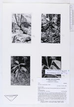
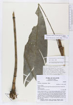
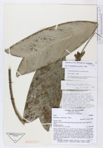
| Family | Arecaceae |
| Identification | Geonoma stricta var. stricta (Poit.)Kunth |
| Determined by | F. Borchsenius |
| Identification qualifier | |
| Field notes | Solitary understory palm, ca. 1.5 m tall. Stem ascending smooth, ca. 8 mm diam, brownish, nodes ca. 4 cm apart, the base swollen with adventitous buds. Leaves 11, spaced along the upper 20 cm of the stem, sheath open on lower leaves, closed on upper ones, petiole and sheath 13 cm long, rounded below, flat above 2-3 mm wide; blade entire, 30 x 10 cm bifid at apex. Inflorescences in axils of lower leaves, peduncle 1 cm long, 5 mm wide, flowering part simple spikelike 4 cm long, 1 cm wide, bracts one (?) (prophyll) ca. 1 cm long, fruits bluish black when ripe, 8 mm long, 5 mm wide. |
| |
| Display all 90 georeferenced records of Geonoma Geonoma stricta var. stricta |
| New Search Modify Search |