AAU Herbarium Database |
| New Search Modify Search |
| Collector | Balslev, H. |
| Number | 62029 |
| Collected with | Henderson, A. & Borchsenius, F. |
| Country | Ecuador |
| Subpart | COTOPAXI |
| County | |
| Locality | 20 km east of La Maná on road to Latacunga from Quevedovia Pilaló. Montane forest on steep slope. |
| Coordinates | 0° 53' S 79° 4' W |
| Minimum elevation (m) | 1100 |
| Maximum elevation (m) | 1100 |
| Start date | 1986/04/06 |
| End date | 1986/04/06 |
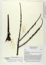
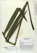
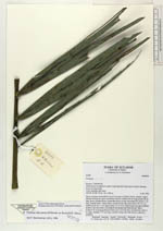
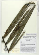
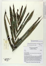
| Family | Arecaceae |
| Identification | Prestoea decurrens (H.Wendl. ex Burret) H.E.Moore |
| Determined by | Borchsenius, F. (AAU), 1996. |
| Identification qualifier | |
| Field notes | Stems cespitose, procumbent, up to 2 m long 4 cm diam. brown, densely ringed. Sheaths forming an 'open' crownshaft, fibrous, reddish, 60 cm long; petiole 60 cm long, green, rounded below, channelled above at base, becoming flat; rachis 1.2 m long, rounded below, ridged above; pinnae 26 per side, basal pinna 18 x 0.5 cm, middle pinna 46 x 4 cm, apical pinna 15 x 0.5 cm; inflorescence just past pistillate anthesis, red, horizontal, with prophyll and peduncular bract already fallen; peduncle 22 cm long (peduncular bract scar 7 cm from base of peduncle); rachis 5 cm long; rachillae 7, 27 cm long ( swollen at base and with flowers sunken in rachillae). |
| |
 Other records of Prestoea decurrens Other records of Prestoea decurrensThe map displays only records from the Aarhus Herbarium Database. The records may not represent the full distribution of Prestoea decurrens |
| New Search Modify Search |